
Editor’s note: The story is about a photograph taken on April 23 in 1936 by a government photographer, Arthur Rothstein. Rothstein’s boss, Roy Stryker, was born and spent his early years in Great Bend. But it is also about the struggles and perseverance of the people that call our region home.
Looming before me is a large photograph of a farmer and his two sons fleeing a dust storm. It’s precisely this stunning artifact that’s drawn me to the Cimarron County Heritage Center in Boise City, Oklahoma.
The image was created on April 23, 1936 by Arthur Rothstein, an investigative photographer with the federal Resettlement Administration. Rothstein’s trek that spring had led him straight into a wasteland — a world reeling from an apocalyptic drought, its people devastated by nature and the Great Depression.
I’ve driven the same route Rothstein took from Amarillo 90 years ago, arriving at the museum in the hope of better understanding how his image became such a poignant symbol of the Dust Bowl.
The 100-mile drive took two hours, but it feels as though generations have elapsed.
Leaving Amarillo, I was greeted by gently rolling hills, cattle and gas country. Back then, road signs told the miles to the next ranch rather than the next town.
That was a time when the Masterson Ranch spanned two counties, 27 miles north of Amarillo. In 1918, the ranch covered 122,000 acres and supported a herd of 8,000 cattle. Then the Standard Oil Company of New Jersey drilled its first gas well here, on what would, at the time, become the world’s largest natural-gas field.
In 1926, an oil gusher at the Smith Ranch, in Carson County, one county to the east, ignited an oil boom.
In the spring of 1936, Rothstein traveled this road in his government-issued 1935 Ford sedan. He encountered 49 active natural gas plants, 29 carbon black plants, thousands of oil wells pumping crude, and a few boom towns turned ghost towns.
As I headed farther north and west, near Hartley, Texas, the terrain flattened into a seemingly endless stretch of farms.
Ahead of me spread the Oklahoma Panhandle, beyond—Western Kansas, both among the largest expanses of flat land in the United States. I navigated a long S-curve — a design feature occurring every 24 miles to account for the Earth’s curvature — and crossed the border into Oklahoma.
The view was vast and uninterrupted.*
Thirty miles in my rearview mirror, nearly all the land surrounding Hartley was planted with row crops, such as sorghum and soybeans, irrigated by center-pivot sprinklers. In Oklahoma, cultivated acreage dwindles, and the crop of choice is wheat, using the traditional dryland method that depends on the Almighty for the right mix of sunshine and rain. Even so, many Oklahoma fields are fallow, nothing but bare dirt.
This is the same land on which in 1931, local farmers celebrated a $2 million harvest, reaping a record 272,600 acres of wheat. The yield was an impressive 21 bushels per acre. It was a familiar story, as the crop cycle reliably repeated itself year after year. Seeds would germinate in the fall, survive winter frosts, then sprout and thrive in the spring. By early June, the stalks reached two feet, heads brimming with grain, transforming fields from green to shades of yellow and gold.
However, the lives of these farmers changed drastically when a drought gripped the region in ‘32. Although more than 300,000 acres of wheat were planted that fall, only 3,000 acres were harvested the following summer, yielding just $7,000 for the entire county. Prospects were equally bleak the next three years. They hoped-for autumn rains brought just enough moisture for farmers to put in their wheat, but not much more. As winter winds began to blow, they swept away fragile shoots and sent vast amounts of topsoil into the air.
New Year’s Day 1936 brought a light snowfall that provided needed moisture and helped settle the dust that swirled for the third consecutive winter.
A month later, on Valentine’s Day Eve, a massive dust cloud boiled into the Panhandle from the north. This grit storm was reminiscent of the big cloud from the previous April; that cloud, the Black Sunday storm of 1935, had been the biggest duster in recent memory.
The Valentine’s Day duster lasted two days and covered more territory than the Black Sunday storm, extending 300 miles east from the Rocky Mountains, from the southern plains of Texas into northern Nebraska. Dust settled on the Atlantic seaboard, just as it had in ‘35. Although no more violent than past storms, its cumulative effects were more disastrous.
During consecutive days in March 1936 — the 11th, 12th, and 13th — a series of dusters cloaked the Panhandle in a saffron gloom. Hopes plummeted. It seemed increasingly likely that spring’s dust storms would be more devastating than those of ‘34 or ‘35, especially since the soil was already as fine as talc.
Two more dusters roared through the Panhandle before April arrived. On April 1, another gale stirred up tons of silt, dimming the sun to a mere candle glow. Unlike the March dusters, this one did not sweep along the ground but hovered high in the air, settling over the countryside like a shroud. Farmers were at least grateful for this, as their wheat was spared a complete blow out.
As March became April, the only things seemingly keeping hope alive were prayers and the new tillage methods introduced by the Resettlement Administration. However, without rain, even those efforts would be insufficient to guarantee a wheat harvest.
During the first week in April, the dust blew every day. The wheat crop suffered even more and was deemed beyond redemption.
Come the 10th of April — nearly a year to the day after Black Sunday — a curtain of heavy dust, up to 16,000 feet thick, rolled over a 400-mile-wide path through the intersection of Colorado, New Mexico, Kansas, and the panhandles of Oklahoma and Texas.
In the aftermath, more farm families, all hope for their crops gone, began packing up and joining the exodus.
Arthur Rothstein was working in New Mexico at the time, part of Roy Stryker’s team of photographers. Stryker, the visionary leader of the photography team at the Resettlement Administration in Washington, D.C., pioneered what would later be known as photojournalism and sent his team—including Dorothea Lange, Russell Lee, and Walker Evans—across the countryside to capture the devastating effects of the Great Depression and the Dust Bowl. In a pivotal letter to Rothstein, Stryker stressed the need for images of the dust storms’ destruction. He directed the 20-year-old Columbia University graduate to travel to Amarillo, then head north into the heart of the disaster.
April 13, 1936
Dear Arthur,
Just received your letter of April 6 from Taos, New Mexico, and also the negatives, which look very good. Your dust pictures were most excellent. . . . On your way north, I believe it advisable to pick up a few more of the ranch scenes, including such things as the dust blown up over the barns and fields and crops covered with dust. . . .
I realize this is a bad time of the year for getting photographs illustrating agricultural methods. However, you will have to take what you can get. I have written Caufield that you will spend a short time with him . . . and could possibly do a little work if it wouldn’t take you too many miles away from Amarillo. When you finish with Caufield, you will start north again, taking more dust pictures en route. Then report to Mr. Jordan in Lincoln (Nebraska).
I want to warn you about the cameras in that dust. If possible, you will have to send them in for cleaning.
Best regards,
Roy E. Stryker
Photographs and Memories
I lifted the glass window with one hand and reached into the display case with the other to feel the powder inside. I grabbed a handful and held it above the box, watching it slip easily from my clenched fist. This dirt—Dust Bowl dirt—tells its own story about the destructive force unleashed by the dust storms of the 1930s.
The pulverized dirt display at the Cimarron County Heritage Center came from a farmhouse 17 miles north of Boise City where James and Milley Nidey lived for nearly half a century. This dirt, accumulated between the shingles, was uncovered during a roofing project after World War II.
Next to the box of dirt is Arthur Rothstein’s iconic 1936 photograph of Cimarron County farmer Art Coble and his young sons fleeing an advancing duster. The 11x14 framed photo is identical to the image displayed on the portable banner at the entrance. That banner features large, bold yellow letters on an olive-green background, reading “Dust, Drought, And Dreams Gone Dry.” Smaller print states that Dust Bowl farmers “thought they could overcome the area’s variable weather and climate. The 1930s disaster taught them they were wrong.”
More photographs hang from panels lining the walls, each suspended by twine. They depict dark clouds billowing as they approach Boise City. Many prints have dates inscribed in chalk. Among them are the Associated Press photo of the Black Sunday storm and Stowe Martin’s haunting image of a black cloud over his house. In Martin’s photo, some people saw the face of an eerie old man in the cloud formation.
The images are ominous, yet none is as powerful as Rothstein’s photo of the Cobles. Still, I persist in my quest to uncover the root of the resilience it captures.
Museum director Jody Risley guides me to a cluttered desk in a quiet corner where I set up a temporary workstation. Nearby are several wooden file cabinets labelled “Dust Bowl Files.” The drawers hold a collection of newspaper clippings, photos, and typed pages, stored in plastic sleeves inside manila folders; offering personal perspectives behind the artifacts on display.
The files are loosely organized, there is no index card. I examine the drawers from front to back, unsure what each manila folder may contain. As I thumb past a folder of poems, I hesitate, then pull out a single typewritten sheet with a three-line verse:
Ashes to ashes and dust to dust;
The men folks raved and the women folks cussed;
Take it and like it: In God we trust
It’s unsigned.
The published articles number in the hundreds—too many to read in one sitting. I scan headlines, read some first paragraphs, and sometimes finish an entire story. A newspaper account from March 1936 quotes farmer Braham Adams from nearby Dallam County. I jot down his quote:
“Maybe the land will blow, and maybe the government experts will help us stop it, but regardless, there’s going to be wheat and beef out here till hell freezes over.”
Adams’ quote feels prophetic, echoing the resilience of the human spirit that Rothstein captured that spring—a series of photos of Oklahoma and Kansas farmers who leaned into the challenge. It’s exactly the kind of testimony I’m seeking.
I read an Ada Evening News story from the aftermath of Black Sunday in April 1935. A headline reads, “Dry-Land Folk To Stick It Out.” There’s a quote from farmer J.R. Peters, who lived near a “crust-blown cemetery just south of Boise City” and had been farming in the Panhandle for almost 20 years, though he hadn’t had a crop since ’31:
“All that is keeping men, and a lot like me, on this land, is the benefit payment the government is making. We get about $1 an acre for our wheat lands.”
I make a note about J.R. Peters.
Other documents suggest that not everyone welcomed government aid. Some took out government loans for feed and seed, with the understanding that the money would be repaid when the first crop was harvested. However, for many, that harvest never came.
Toward the back of the drawer is a hidden treasure, a folder containing transcripts from an Oklahoma State University oral history project conducted in 2001. These transcripts provide detailed accounts from dozens of Dust Bowl women. Their stories are presented as fully as the years allow, reflecting raw and unedited memories.
Several focus groups, each comprising two to four women, included participants who shared more than just the Dust Bowl experience: they were teenagers living in Cimarron County. Some were born here, while others had migrated from Kansas, Arkansas, Missouri, Iowa, Illinois, or Ohio. Most recall their arrival in the Panhandle.
Boise City was just getting started when their families arrived here. The little town offered many of the same conveniences of the places they had left behind. Kids rode horses to school, and roller-skated around the courthouse square, which was the only paved sidewalk in town.
Opal Burnett Blancett was 83 when she was interviewed by OSU students in 2001 about her Dust Bowl experiences. She was 17 in 1935, the year of the worst storms. Her father, Dunn Burnett, had arrived in the Panhandle with his parents from Colorado in 1889. He later ranched along the Cimarron River with his wife, Lona, where Opal was born. Opal recalled:
My mother and I were in the house. There was hardly any wind. It just rolled in. It was coal black. The Black One, we called it. My mother started praying. She thought it was the end of the world. We’d seen a lot of dirt and dust and things blowing every day, but not anything like that.
The Black One struck at 5:15 p.m. on April 14, 1935, and lasted six hours. The dust was so thick that it extinguished lamps and stoves because of a lack of oxygen. For more than an hour, it was pitch-dark, and people kept wet cloths over their faces to breathe. It wasn’t the only storm of record, just one of the worst. In the four years leading up to Black Sunday, there had been over 300 dusters. Each new storm destroyed still more ground, leading to still more and worse storms.
Following Black Sunday in April 1935, government relief finally began to arrive. The Soil Conservation and Extension Services experimented with erosion-control techniques, such as listing and chiseling. They used a lister plow to create furrows perpendicular to the prevailing winds, and a chisel plow to bring hard clods to the surface and weigh down loose topsoil. To encourage adoption, affected farmers were offered between 10 and 40 cents an acre if they agreed to plow along contour lines, following the natural lay of the land rather than plowing straight lines.
These new farming practices, along with other government programs, not only supported farmers in their fields but also bolstered the many small towns that had sprung up as rural trading centers.
Although federal relief efforts were expanding nationwide, their ultimate effectiveness remained uncertain. In mid-April 1936, Arthur Rothstein was in Taos, New Mexico, when he received the general-delivery letter from Roy Stryker instructing him to proceed to Amarillo, Texas, and report to a man named John Caulfield, the Chief of the RA’s Land Use Planning Section.
Further Down the Road
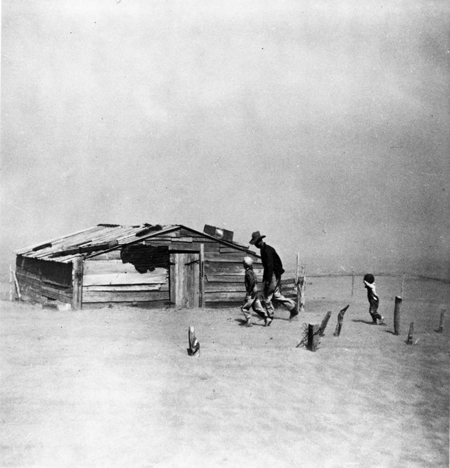
Arthur Rothstein was the youngest and the first hire on the Resettlement Administration photography team. Over time, his “Farmer and Son” became one of the most familiar images from the era. Alongside Dorothea Lange’s “Migrant Mother,” his image of a farmer and his sons caught in a dust storm in Cimarron County, Oklahoma, on April 23, 1936, bookends the devastating impact of the Dust Bowl.
Nothing tells the Dust Bowl story as simply and powerfully as these two photographs. No newspaper article comes close to capturing the experience of being caught in a bad duster or what life was like during the Dust Bowl years as effectively as they do.
After spending a day reviewing hundreds of old files at the Cimarron County Heritage Center to better understand how Rothstein’s image became such a poignant symbol of that time, I still hadn’t found my answer. There are as many perspectives on life during the Dust Bowl as there are people who lived through it. Why, then, is one particular image—showing a man leaning into the wind with his sons following his lead, shielding their faces from the blowing dust—regarded as the signature portrait of this struggle between man and nature?
The accounts filed away in the Boise City museum recount stories of days when dust obscured the sun, fields were blanketed in silica dust, and dust pneumonia affected people of all ages. All these stories are preserved as part of the historical record. Still, I am searching for something specific: the prose behind Arthur Rothstein’s photograph of a man pursuing his dreams, even as the ground beneath him retreats with each gust of wind.
Neither the documents I reviewed nor the artifacts on display at the Center provided that story.
As I gathered my belongings and prepared to leave, I couldn’t shake the feeling of being lost in the dark, much like the individuals portrayed in the storm images that filled the walls around me.
Near the front door of the center, I ran into its director, Jody Risley. She came out of her office to ask if I had found what I was looking for. I asked if she knew the Coble place, where the Rothstein photo was taken.
Nearby, on a couch in the reception area, sat an expert on Cimarron County roads: her husband, Fred. A retiree of the county road department, Fred Risley knew how to find it.
As he recited directions from memory, she sketched a map on a Post-it note. The hand-drawn map accurately depicted the roads just as they had been for the past century—nothing had changed except their numbers and surfaces.
Ninety years ago, in April 1936, 20-year-old Arthur Rothstein traveled west of the Mississippi River for the first time, working as an investigative photographer for the Resettlement Administration (RA). A recent graduate of Columbia University, Rothstein grew up on Amsterdam Avenue in the Edenwald section of the Bronx and had spent his entire life in New York City. Before joining the RA, he had never driven a car or ventured outside the city. This lack of experience, rather than being a hindrance, became one of his greatest assets, granting him a unique perspective on American life as he explored a new world beyond the city limits.
He arrived in the Texas Panhandle around April 19, coinciding with the rollout of the new wind-erosion control programs. He reported to the RA’s offices located at Third and Polk in downtown Amarillo, where he was assigned to accompany H.H. Finnell on visits to RA clients in the surrounding area.
Finnell, the regional director for the Soil Conservation Service, had been battling soil erosion long before the Dirty Thirties began. As a soil scientist and director of the Goodwell Experiment Station at Oklahoma A&M, he spent 15 years getting to know the soil and almost every farmer tilling it in the Panhandle.
In his new government role, Finnell was tasked with expanding the government’s efforts to include the tillage techniques he had experimented with in Goodwell. As they toured the countryside, from Muleshoe to Dumas, the pair observed farmers using these new techniques and equipment.
Three days later, on April 22, Rothstein set out from Amarillo for Lincoln, Nebraska, a journey taking him directly through Cimarron County and Boise City, the heart of the Dust Bowl. Finnell provided an overview of what to expect in Cimarron County and where the worst conditions existed.
In the back seat of his 1935 Ford, Rothstein packed several cameras, including a Graflex 3¼ × 4¼-inch Speed Graphic, a 35mm Leica, and an inexpensive Ikonta miniature, along with photo flash equipment and three dozen rolls of Agfa Plenachrome 35mm black-and-white film on wooden spools. In the trunk were a sleeping bag, a portable stove, an axe, and a shovel.
Back in Washington D.C., the national news media were hounding Stryker for images of the Dust Bowl. In response, he compiled a shot list for Rothstein that included dust-buried barns, fields, crops, and farm equipment. Additionally, he stressed the need for photographs of people in their surroundings, farmers going about their days—pictures that told stories.
Seventy miles northwest of Amarillo, in Hartley County, Texas, Rothstein, the shot list tucked in his pocket, stopped to photograph a dilapidated windmill, windswept fields, soil drifting against a barn, and buried fence posts.
North of Dalhart, Texas, midway through the long S-curve that divides Oklahoma from Texas, the highway designation changed from Texas 51 to Oklahoma 70. He was in Cimarron County.
Rothstein veered off the highway onto a dusty back road, searching for farmers enrolled in the new subsidy program. Three miles from the highway, he came across Arthur Coble and his two young boys, who were outside doing chores.
For most of the afternoon, Rothstein followed the tall, lanky Coble, taking numerous photographs. Years later, he recounted for the Smithsonian the exact moment the famous photo came together: he was packing up to leave when he turned to wave goodbye. At that moment, Coble and his sons were walking past a shed and heading to the house, with the youngest boy trying to keep up as a cloud of dust began to swirl. It was the kind of photo Roy Stryker requested—people in their environment—and it was there for but a second.
After leaving the Coble place, more scenes on Stryker’s shot list appeared as he neared Boise City. By the time he reached town, he had taken 77 photos in total.
Downtown Boise City was not much different than any other town he had visited that spring. At its center stood a stately courthouse, and the lights of a movie house cast a familiar glow. The Palace Theater’s marquee advertised that evening’s film, “Moonlight on the Prairie,” starring Dick Foran and Sheila Mannors, starting at 7:45 p.m. At the post office, he sent his film negatives off to Roy Stryker in Washington, D.C., along with this handwritten note:
Boise City, Cimarron Co., Oklahoma
Thursday, April 23, 1936
Very dusty wind about 25 miles hr.
Went out with Farrel, rural rehab supervisor and photographed a number of rehab clients and their badly buried fields and farms. Farrel says this is the worst section of the “dust bowl” - An area about 30 square miles was originally settled by Missouri and Ohio farmers who plowed up the wrong type of soil and used Ohio farming methods. This section is now a complete desert and is the cause of most of the destruction in the Panhandle. I took 77 pictures.
Proceeding to Lincoln Neb.
Arthur
In the summer of 2025, I parked my Lexus SUV about 20 feet off the dirt road, three miles from the highway S-curve. I had followed a couple of ruts to the approximate spot marked with an X on the hand-drawn map by Jody Risley. This is where Arthur Rothstein would have stood 90 years ago.
The old Coble place no longer exists, and the dirt landscape in the photo is now covered with dark green plants as far as I can see. From this spot, I imagine Arthur Coble, the man in the photo. He was an everyman whose struggles mirrored those of ordinary people who did whatever it took to survive. Like everyone else, he didn’t recognize the extent of his poverty because nobody else had much of anything either.
It is here, on this same patch of ground, that I finally understand the significance of Rothstein’s photograph, “Farmer and Sons.”
While Lange’s “Migrant Mother” symbolized the fraught journey of the Okies and connected with the struggles and exploitation of those impoverished refugees, “Farmer and Sons,” on the other hand, reflected the Sooner spirit embodied in those who chose to stay on their land because it was where they belonged. It’s a symbol of defiance and survival.
Arthur Rothstein had captured the essence of the Dust Bowl and the people who lived through it. A year later, on April 11, 1937, his photo of Arthur Coble and his sons was featured prominently on the front page of section eight of The New York Times Magazine, illustrating a story by Harlan Miller, who wrote, “when the dust rises and storms across the land... it numbs and paralyzes and obliterates.”
This is the Dust Bowl.
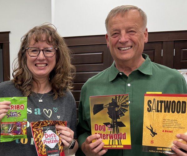
Jim Arwood is a retired newspaper editor who spends his days traveling and documenting stories he finds along the way. He is originally from Lyons, Kansas and attended Barton County Community College in 1975. Contact him at:
jimarwood@cox.net